Monday, April 10, 2006
The Manning’s Coefficient of Roughness
Roughness coefficients represent the resistance to flood flows in channels and flood plains. The results of Manning’s formula, an indirect computation of stream flow, have applications in flood-plain management, in flood insurance studies, and in the design of bridge and highways across flood plain. Roughness values for flood plains can be quite different from values for channels; therefore, roughness values for flood plains should be determined independently from channel values. As in the computation of channel roughness, a base roughness (nb) is assigned to the flood plain and adjustments for various roughness factors are made to determine the total n value for the flood plain. The most important factors that affect the selection of channel n values are the type and size of the materials that compose the bed and banks of the channel and also the shape of the channel (Arcement, Schneider).
Although much research has been done on Manning’s coefficient of roughness, n, for stream channels, very little has been done concerning the roughness values for densely vegetated flood plains. The n value is determined from the values of the factors that affect the roughness of channels and flood plains. In densely vegetated flood plains, the major roughness is caused by trees, vines, and brush. The n value for this type of flood plain can be determined by measuring the vegetation density of the flood plain. Barnes (1967) catalogued verified n values for stable channels having coefficients of roughness ranging from 0.024 to 0.075 (Arcement, Schneider), where as the stable channel can be defined as a channel in which the bed is composed of firm soil, gravel, cobbles, boulders, or bedrock and the channel remains relatively unchanged throughout most of the range in flow.
The coefficients of roughness apply to a longitudinal reach of channel and/or flood plain. A hypothetical reach of a channel and flood plain is shown in figure left. The cross section of the reach may be regular geometric shape (such triangular, trapezoidal, or semicircular) or of an irregular shape typical of many natural channels. The flow may be confined to one or more channels, and, especially during floods, the flow occur both in the channel and in the flood plain.
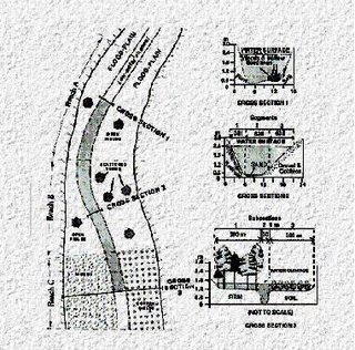
Figure: A Schematic and Cross Sections of Hypothetical Reach of a Channel and Floodplain Showing Subdivisions used in Assigning n Values. (Resources: United States Geological Survey Water-Supply Paper 2339)
Although much research has been done on Manning’s coefficient of roughness, n, for stream channels, very little has been done concerning the roughness values for densely vegetated flood plains. The n value is determined from the values of the factors that affect the roughness of channels and flood plains. In densely vegetated flood plains, the major roughness is caused by trees, vines, and brush. The n value for this type of flood plain can be determined by measuring the vegetation density of the flood plain. Barnes (1967) catalogued verified n values for stable channels having coefficients of roughness ranging from 0.024 to 0.075 (Arcement, Schneider), where as the stable channel can be defined as a channel in which the bed is composed of firm soil, gravel, cobbles, boulders, or bedrock and the channel remains relatively unchanged throughout most of the range in flow.
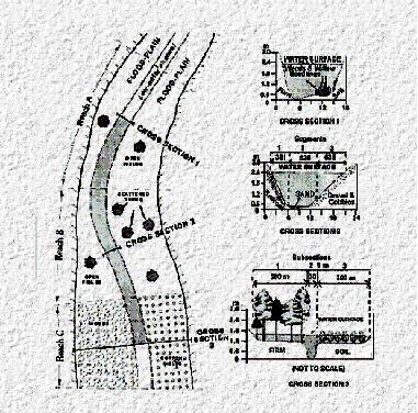
The coefficients of roughness apply to a longitudinal reach of channel and/or flood plain. A hypothetical reach of a channel and flood plain is shown in figure left. The cross section of the reach may be regular geometric shape (such triangular, trapezoidal, or semicircular) or of an irregular shape typical of many natural channels. The flow may be confined to one or more channels, and, especially during floods, the flow occur both in the channel and in the flood plain.

Figure: A Schematic and Cross Sections of Hypothetical Reach of a Channel and Floodplain Showing Subdivisions used in Assigning n Values. (Resources: United States Geological Survey Water-Supply Paper 2339)
# posted by Faizul Izwan @ 5:21 AM 
![]()